
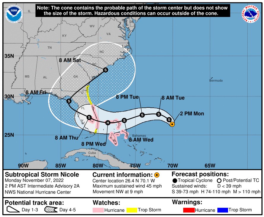
Subtropical Storm Nicole has prompted hurricane, tropical storm, and storm surge alerts as a prolonged period of coastal flooding, beach erosion, strong winds, high surf, rip currents, and heavy rain is expected in Florida and parts of the Southeast this week.
Nicole became the 14th Atlantic season storm early Monday morning storm and is centered several hundred miles east of the Bahamas.
The storm has been classified as subtropical, meaning it's a hybrid type system with characteristics of both a tropical and non-tropical storm. Nicole is forecast to transition into a fully tropical storm in the next day or so.
A hurricane warning has been issued for parts of the northwestern Bahamas, including Freeport, Grand Bahama. This means hurricane conditions are expected in the area, in this case, by early Wednesday.
Tropical storm warnings have been issued in Andros, New Providence, and Eleuthera islands in the Bahamas, including Nassau, where tropical storm conditions are expected in the next 36 hours.
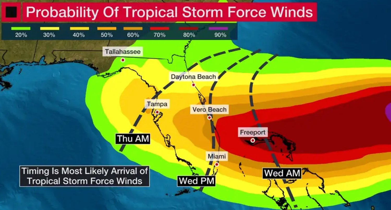
A hurricane watch has been issued in eastern Florida from the Space Coast south to Hallandale Beach in Broward County, including Lake Okeechobee.
Tropical storm watches extend south to Miami-Dade County and extend north of the Space Coast into Glynn County, Georgia, including Daytona Beach and St. Simons Island.
A storm surge watch is also in effect from Glynn County, Georgia, to Broward County, Florida, as well as a stretch of the St. Johns River in northeast Florida from East Palatka to where it empties into the Atlantic Ocean north of Jacksonville Beach.
From the Orange County Newsroom
Orange County remains under a Local State of Emergency and is one of 34 counties in Florida under a State of Emergency for Subtropical Storm Nicole.
The National Weather Service issued a Tropical Storm Watch for Orange County at 11 a.m. today. A Hurricane Watch is in effect for the coastal Central Florida counties, including Volusia and Brevard.
Sandbags
Orange County residents are urged to prepare now for this storm. The county will have four self-serve sandbag locations open on Tuesday, November 8, from 8 a.m. to 5:30 p.m. These locations are:
Residents will need to bring their own shovels and will be provided up to 10 bags to fill. Residents must also provide a valid photo ID with an Orange County address.
Debris
Orange County Utilities and Public Works have been working around the clock since Hurricane Ian to remove yard waste and storm debris from residents’ yards. To date, more than 150,000 cubic yards of debris have been picked up in the county.
There is more debris that still needs to be collected. Residents are asked if they still have debris in their yards to try and keep it from washing down the storm drains. Please get debris off the streets and onto the front yards, away from the street.
Schools
Orange County Public Schools are closely monitoring the storm with the National Weather Service and the Orange County Office of Emergency Management. At this time, no decision has been made to cancel school or extracurricular activities.
Election Day
Tomorrow is Election Day. Elections Supervisor Bill Cowles is preparing all the voting sites. The impending storm will not impact your decision to exercise your right to vote.
The St. Johns River Water Management District is closely monitoring Subtropical Storm Nicole and is taking proactive measures to help manage the anticipated rainfall in the coming days.
· The District’s emergency operations team is monitoring the storm’s path and water levels to provide information to the public and be prepared to assist local government partners and other regional and state agencies as needed.
· Anyone located along the St. Johns River, especially in central Florida where moderate and minor flooding are still occurring from Hurricane Ian, will want to monitor rainfall forecasts and river levels as levels are expected to rise with this storm event. Current river levels can be viewed on the District’s website at www.sjrwmd.com.
· Additionally, tides and storm surge from the ocean influence the middle and lower St. Johns River. Water levels in the northern reaches of St. Johns can rise with little advance notice.
All property owners should act now to be prepared for the storm’s rains by:
Be sure to follow your county’s Emergency Operations Center for the latest local emergency updates. They serve as the primary entities responsible for emergency responses during storms, including implementing state-of-emergency declarations, evacuations, and rescue efforts during flood-related disasters. The District may assist local governments in their response and recovery efforts.


Comments
No comments on this item Please log in to comment by clicking here